![]() Background analysis:
Background analysis:
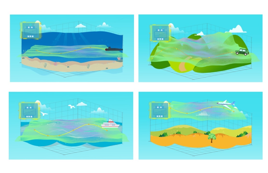
Navigation is a general term for the technical category, which refers to a technical means to guide airplanes, ships, vehicles and individuals (collectively referred to as carriers) to safely and accurately follow a selected route and arrive at their destination on time. Nowadays, with the rapid development of communication technology, people have an increasing demand for location-based navigation services. Inertial navigation system (referred to as inertial navigation) requires initial alignment and will result in large cumulative error if operates for a long time. The satellite navigation receiving terminal can provide high-precision 3D position, speed and time information in an all-weather, real-time and continuous manner, without cumulative error, and is suitable for static, low and high dynamic carrier navigation. However, the terrain environment occlusion restriction makes it susceptible to be interfered by other radio signals. GPS and GLONASS, Galileo, and Beidou all rely on satellite positioning and navigation. Sometimes satellite signals in remote areas or deep in the ocean are weak or even in blind spots. The geomagnetic navigation has the special advantage of being less susceptible to human interference and gradually enters people's field of vision. In September 2014, Baidu invested in a research and development company for geomagnetic positioning and navigation technology. The indoor geomagnetic positioning and navigation data acquisition and application system developed by the company is effective and can basically deliver the desired accuracy. As a passive autonomous navigation method, geomagnetic positioning and navigation technology has strong anti-interference ability, and moderate accuracy with no accumulated error . It is also the only navigation system that can work normally without being affected by external factors. Geomagnetic positioning navigation is not only suitable for underwater, underground, and high-altitude navigation, but also for urban navigation.
![]() Design Plan:
Design Plan:
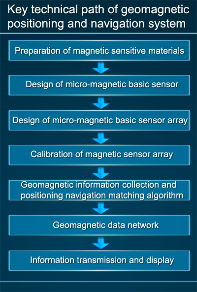
The geomagnetic positioning and navigation system, with Guochuang Micro-magnetic Basic Sensor as the core component can be equipped on civil ships, aircrafts, UAVs, vehicles, robots and other carriers.The micro-magnetic basic sensor can collect the geomagnetic information in a real-time manner, compare them with those in the existing geomagnetic database, update the real-time geomagnetic information map, and utilize the corresponding navigation model and algorithm to realize the geomagnetic positioning and navigation.
![]() Advantages of geomagnetic navigation:
Advantages of geomagnetic navigation:
Compared with the traditional GPS, inertial navigation, GLONASS, Galileo, and Beidou, the geomagnetic positioning and navigation is more reliable, confidential, stable and accurate in underwater, indoor and other special environments, and has strong comprehensive advantages. Geomagnetic survey is not restricted by location and environment and can realize all-weather and all-region navigation; and it is a passive measurement, with high concealment. The navigation error of the geomagnetic matching positioning method will not accumulate over time. The geomagnetic field is a vector field that can provide abundant navigational reference information.
![]() Technology roadmap of geomagnetic positioning and navigation:
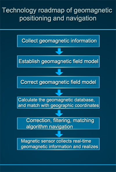
Technology roadmap of geomagnetic positioning and navigation:
Firstly, it collects the geomagnetic information by aerial survey or other means to establish a geomagnetic field model, and observes the geomagnetic data using the seismic observatory to compensate and correct the geomagnetic model, calculate the geomagnetic field database based on the modified model, and correspond to the geographic coordinates provided by Beidou system. Mount a magnetic sensor with high response speed on the carrier for geomagnetic survey, survey the characteristic quantity of magnetic field in the region and draw a real-time online map, perform correlation matching by comparing the actual diagram and the reference diagram, calculate the real-time coordinate position of the carrier, solve the navigation pattern matching information for the carrier, form a digital model of the 3D geomagnetic map; correct the navigation system using the magnetic vector matching information, filter the navigation system by taking the comparison result of the geomagnetic diagrams as the Kalman Filter observation, define the deviation of the guidance direction and the target direction, and of the guidance direction and the forward direction, position of the navigation object; achieve high-precision positioning and navigation by mature technologies such as path planning and control strategy.
![]() Principle:
Principle:
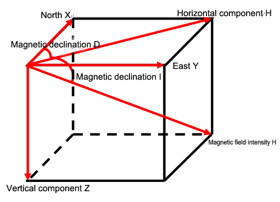
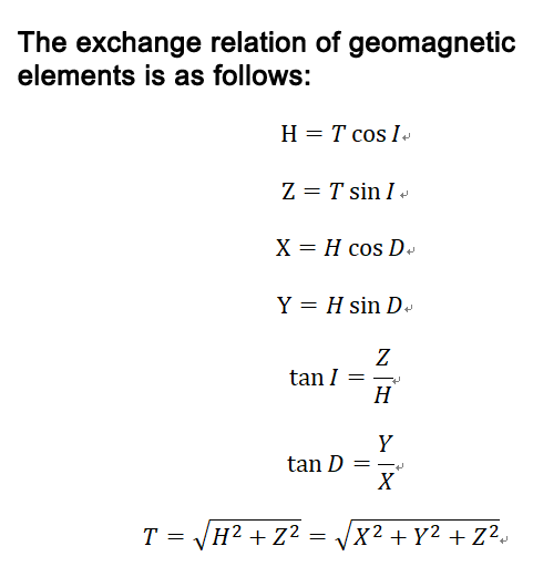
The geomagnetic field is a stable and reliable natural resource, the geomagnetic resources is public, and the geomagnetic vector at each point on the earth is uniquely determined. In a Cartesian coordinate system, there are 7 geomagnetic elements: magnetic declination angle D, magnetic inclination I, total geomagnetic field intensity T, vertical geomagnetic field intensity Z, horizontal magnetic field intensity H (including horizontal X component (north), and horizontal Y component (east)).
![]() Technical solution:
Technical solution:
1. The geomagnetic positioning and navigation system is composed of micro-magnetic basic sensor array,
2. The micro-magnetic basic sensor array is installed in the geomagnetic positioning and navigation system free from the motor interference;
3. Related algorithms include: calibration of the soft and hard magnetic interference of the carrier, calibration of installation error, carrier noise suppression, abnormal small signal processing, matching navigation, etc.;
4. Network data center: collection of data and information such as micro-magnetic basic sensor array data and magnetic anomaly positioning signals;
5. Terminal console: display the working status and parameter information of the magnetic positioning and navigation system.
